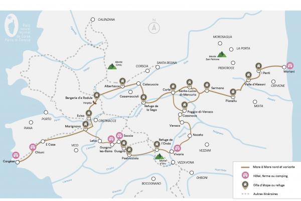
FROM MORIANI TO CARGESE
Moriani – «I Penti» (Santa Riparata di Muriani): 3 hours 30 minutes
«I Penti» (Santa Riparata di Muriani) – E Valle d’Alisgiani: 4 hours 30 minutes
E Valle d’Alisgiani – Pianellu: 5 hours 30 minutes
Pianellu – Sermanu: 4 hours 50 minutes (departure of the variant from Sermanu)
Sermanu – Corte: 5 hours (possible junction to the variant in Corte)
Corte – «A Sega»: 5 hours 30 minutes
«A Sega» – Albertacce: 5 hours 10 minutes
Albertacce – Bocca a Verghju: 4 hours 40 minutes
Bocca a Verghju – Marignana: 4 hours 30 minutes
Marignana – «E Case»: 6 hours 30 minutes
«E Case» – Cargese: 5 hours
3 STAGES IN CASTAGNICCIA MARE È MONTI
The first three stages are on our territory, starting from Moriani-Plage. At the main cross road, take the secondary road D34 in direction of San Niculaiu for around 300 metres, and turn left after the city hall. Continue to a wooden sign on your right, and follow the orange markings.
Stage 1: Moriani - I Penti: 10km / 700m of ascent and 100m of descent
Stage 2: I Penti - E Valle d'Alisgiani: 10km / 700m of ascent and 650m of descent
Stage 3: E Valle d'Alisgiani - Pianellu: 12km / 750m of ascent and 600m of descent


